- Popular Post


AronG
-
Posts
539 -
Joined
-
Last visited
Content Type
Profiles
Forums
Gallery
Project Database
User Guide
Store
Events
Posts posted by AronG
-
-
It's still only halfway through, but it's been incredible to watch the steady progress over the last 5 years on envision cayce. Feels like restaurant/market/mixed use areas is the one big thing that's missing from forming it all into a cohesive neighborhood, so here's hoping that starts to fill in.
-
 4
4
-
-
- Popular Post
- Popular Post
4 hours ago, bwithers1 said:Status Dough has locations in Knoxville in addition to this one in East Nashville. I am not familiar enough with Knoxville to know whether or not those locations are close to chain stores as competition. My guess is that a Dunkin Donuts would be packed, particularly with traffic from in-bound morning commuters, but that the local shops would still be fine.
Similar to the Starbucks. To date, I haven’t heard of any local East Nashville coffee shops closing.
Donut Distillery has raised its profile with a diversity of offerings and events inside the building and in the parking lot. Five Daughters Bakery and East Park Donuts are located in different mini-submarkets and should be fine.
My prediction is also that native East Nashvillians will continue to lament the long-gone Krispy Kreme at Greenwood/Gallatin as though that had been a local independent shop. Nostalgia can be powerful.
It is regrettable that the Gallatin Road UDO that replaced the SP strips out all of the urban placement requirements of even the base zoning on Gallatin. The 7-Eleven is built to the sidewalk and includes a greatly widened sidewalk but is in no way pedestrian focused. Despite its placement that building does the opposite of activating the street. The same would have been true of the original plan for the Publix circa 2007.
That block of Gallatin from Petway to Granada is in need of some new energy in addition to Hearts.
Well, it really needs a 5-story mixed use building lining the block, but assembling enough parcels to do that would be difficult.
While it does not advance the desire to make Gallatin more walkable, this project doesn’t necessarily make things worse. Even most of the local restaurants that have popped up on Gallatin still have the pull-in parking lots that were grandfathered in with the existing buildings that were repurposed. I’m sure that NDOT will be taking a close look at this site plan.
I've never managed to fully understand all the incentives and requirements buried in the UDO vs. the SP vs. the base zoning, but the results are sadly clear lately. Instead of harnessing the new development interest along Main St/Gallatin/Dickerson to add amenities and improvements that lay in the new density in ways that make the areas more pleasant, walkable, transit-friendly, and lively, we're making it easiest for developers to just cram in more car-focused development. So instead of thriving pedestrian districts with human-focused streetscapes, we're getting drive-throughs, gas stations, and parking garages, often fronting the corridor with long stretches of pedestrian dead space. I'm always optimistic that one day the tide will turn, but it's a sad failure of city planning that we're seeing these patterns this close to downtown. Each one locks us into the current dead end a little harder, ensuring most people will continue to have little choice but to drive everywhere they go, and we can all look forward to more traffic and an even more pedestrian-hostile streets.
-
6
-
 1
1
-
- Popular Post
- Popular Post
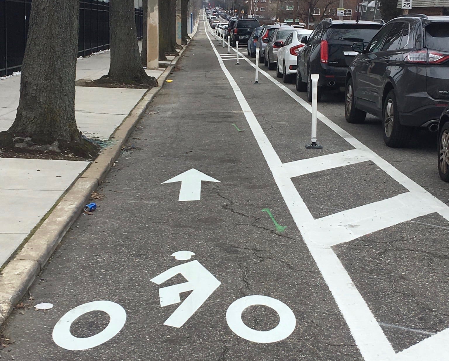
On 12/2/2021 at 6:08 PM, andywildman said:I love that the Spring Street sharrows are considered “existing bike network” on the biking map.
This drives me absolutely crazy, and it absolutely turns most of the planning conversations in this city around pedestrian/bike infrastructure into some kind of stupid pointless ritual.

This is not a bike lane. It is not any kind of bike thing. Riding a bike here would be suicidal. No-one does it, and no-one is ever going to do it. Any idiot that drives the cloverleaf to take a look at this, or even glances at it on a map, knows that. They might as well have painted a picture of a kid in the middle of the interstate and called it a new playground, it would make as much sense.
I have no idea who is responsible for this absurd creation or what bureaucratic rule motivated them to do it, but I assume it's a dim relic of the past. The infuriating thing about it is, why in the name of all that is holy are planning people still drawing maps pretending like this is part of a bike network? Not only is it not a bike lane, it's the opposite of a bike lane. It's a complete, impassable obstacle to anybody on foot/bike trying to get between, say, the east bank, and McFerrin Park, a neighborhood with lots of cool stuff that people might like to frequent without driving.
This isn't some isolated example, either. The vast majority of the planning conversations on bike networks around here use utterly delusional maps. The green lines on this map would make you think that we have an existing bike network to tap into and extend.
The reality is, we have only small, isolated stretches of actual, safe bike lanes that anyone other than a hardened road warrior would use.
Just in this one section, I see Dickerson, Spring St, and Main St included as "existing bike lanes", each of which is completely delusional. And at a quick glance, some of the dotted blue "proposed bike lanes" don't make sense either. Why does this map show a proposed bike lane leading through the cloverleaf and onto Ellington? It's like some kind of joke. "The new neighborhood is going to have great connectivity; here's a new bike lane to get on the interstate!" (?!?) Maybe they're gonna stencil little bicycle pictures onto Ellington and add it to the "bikeway network" too...
For me, I've tried to participate in the Nashville planning process for years, and it's getting hard to play along any more. I've never been able to tell if the planning people are well-intentioned and incompetent on this topic, or if they're just wearily going through the motions to provide a nice greenwashed photo op before we sink a few more hundreds of millions into infrastructure for suburban commuters.
I wish organizations like Nashville walk and bike would call them out more, or at least be more public about what we actually have to work with right now. A realistic map of Nashville from a pedestrian/bike perspective would show a city of islands, connected by a few dangerous corridors that allow the brave or desperate to risk their lives crossing between them. If you've tried to get around this city outside a car, you know this very viscerally, but no one in planning seems able to acknowledge it. The best hope for the East Bank is to create a traffic-calmed island with the density and mix of uses to have good internal foot traffic, and to pick a few corridors in and out and make drastic improvements to enable safe non-car connections to surrounding neighborhoods.

-
12
-
3
-
 1
1
-
- Popular Post
- Popular Post
Sure wish they would make something public about what they're planning with this spine road. They're calling it a new arterial, and between that and the material CM Mendes posted (https://www.mendesfornashville.com/news/transparency) regarding their partnership with the state, it's starting to look pretty likely they're going to run the same old playbook and talk a lot about "multimodal" while they build a road that's 95% designed around high-throughput capacity for interstate commuters. You can't make a road like that pedestrian-friendly just by sprinkling some amenities on the side. I think about this every time I play frogger to get across KVB and 1st.
If we build the east bank with infrastructure that's focused on removing all friction for interstate commuters, that's what the developers are going to build for. And once it's built out with giant parking garages everywhere, it's going to be a lot harder to change patterns. If they go a different route and put in infrastructure that doesn't maximize vehicles-per-minute, but focuses on people instead, the new district can grow to fit.
-
10
-
2
-
Is the city planning any improvements to the greenway in conjunction with this project? Seems like this project could be an incredible new anchor that could draw a significant amount of foot/bike traffic onto the greenway, except it's so run-down and unpleasant right now... Holding out hope the developer is going to try to get some improvements to get more of an ATL/beltline vibe...
-
4
-
-
On 9/28/2021 at 10:44 AM, bwithers1 said:
The notion that neighborhoods originally developed density only gradually in the early 20th Century as populations gradually increased and that it was relatively affordable for most people to build or buy houses or add commercial buildings serving the neighborhoods is a fantasy that is not supported by historical research.Most housing in the urban historic neighborhoods was built by investor landlords on spec close to the streetcar lines. The population was relatively dense because few people could afford to own property themselves, few owned cars, and in the pre-Nuclear Family era extended families tended to live together all in a 2- or maybe 3-bedroom house or apartment and they were lucky if there was indoor plumbing. Even Ross Elementary School on Ordway had outhouses, for instance. Women in most cases could not own property in their own name. And with significant barriers to employment and income, many widows took in boarders into their homes to help pay bills and survive. It is far too easy to paint rosy pictures of what life was like in the past when urban population densities were at their peaks.
While it may not always be the case, Council District 5 is a prime example of gentrification leading to larger houses with fewer occupants, That is literally what is happening there.
Only small areas of the Maxwell and Greenwood neighborhoods have Conservation Overlays that prevent demolition of historic houses. so there aren’t any zoning restrictions on any sizable portion of the area that require renovation rather than building new.
Instead, property owners are free to tear down the overwhelming majority of housing units in District 5. And in the last ten years they have torn down smaller houses that had sheltered larger, extended families and replaced them with much larger houses that shelter a single person or a couple maybe with one child.
The Census data shows the effect of gentrification on District 5, which is much more pronounced than in District 7, for instance. District 7 has had a more stable overall population density even while home values have increased significantly. But District 5 has seen a more dramatic population decline, even as new construction has increased and even as the 2011-2019 District 5 Council Member supported a record number of zone changes to increase housing supply opportunities there.
Almost the entire District 5 area was downzoned to single-family not by some effort to stop integration early in the 20th Century, but fairly recently by then-District 5 Council Member Pam Murray. The purpose of this downzoning was to stop the perceived social and property devaluation issues that occurred in multifamily or what was called at the time “boarding house zoning” when houses were divided up into multiple apartments that mostly served as SROs or where landlords allowed deferred maintenance to occur to a point that housing conditions were substandard and where in many cases tenants with criminal activity issues affected safety and quality of life for the majority African American neighborhoods that she represented. Drug dealing, prostitution and gun violence plagued parts of District 5 until fairly recently through majority African American neighborhood groups working with the East Precinct to address safety concerns.. When those issues were brought under better control, then suddenly the young professionals started moving in.
Zoning was not a major factor in the gentrification in District 5 - the area has had multiple overlapping subsequent upzonings over the last decade. The issue was a newfound and sudden desirability of East Nashville caused by significant reductions in crime, particularly gun violence, paired with significant openings of restaurants, bars and amenities in neighborhoods that were relatively affordable through prior devaluations and that had relatively complete existing sidewalk networks to support walkability.
I do not argue that multifamily zoning necessarily leads to property standards issues and crime. It is that in East Nashville several overlapping issues exerted themselves to make a once desirable area undesirable, and therefore affordable.
Actually, we read that the construction of the railroads in East Nashville was fought by property owners because they were concerned that it would bring noise and air pollution to their properties, and when they lost the lawsuits and the railroads were built anyway, many of those property owners subdivided their properties for sale and left the area.
Another factor was that in the days before mortgages people had to pay cash for houses, and so with no subsequent mortgage payment to deal with many owners of older houses moved away and either divided up their houses into apartments, subdivided them for platted street blocks or simply sold them for development (as happened with the houses along Gallatin where also, a Kroger, etc are located). The widening of Main/Gallatin and Dickerson caused many buildings that had been constructed to the street to be demolished. Interstate and Ellington construction. Lack of Codes at all or enforcement of what may have existed led to poor building maintenance and proliferation of businesses that degraded quality of life. In some cases, property owners or the city itself demolished large portions of neighborhoods as part of Urban Renewal efforts that disrupted intact neighborhoods. In other cases, property owners or the city itself used areas of urban neighborhoods as construction and demolition landfills, etc. More ink has been spilled about redlining, racism and white flight than I could repeat here.
This is all to say that historic urban neighborhoods in the early 20th Century Nashville did not become dense, walkable and complete mixed-use communities through the supposed benevolent forces of an efficient market until zoning got in the way and ruined everything. And it is not necessarily the case that simply rezoning everything to multifamily or mixed use solves all housing supply and social issues.
Most of lower East Nashville actually had multifamily zoning that coincided with (but was not the cause of) declining property standards and community quality of life. Then efforts were made to downzone and increase the specificity of zoning to create the conditions that would attract people to choose to live here again and to make it possible to obtain a mortgage on a home here. Today there is a need for more housing supply and the Metro Council has passed a large number of zone changes to increase density throughout District 5 in particular. But the real estate market is not efficient and there will be lag times until that supply-demand balance catches up. Who knows when the housing market may achieve balance. Then subsequent external factors could cause that housing supply to become oversupply, which would lead to affordability again. Repeat.
Thanks for the response Brett. Your historical context is always interesting, but as ever, I feel like something simple keeps being made more complicated. The historical plight of women, renting vs owning, indoor vs outdoor plumbing, etc. all add interesting color, but are unrelated to the very basic fact that historically, houses were converted to townhomes as demand rose. Townhomes were converted to flats, flats into mid-rises, etc. Supply increased organically to meet demand. The rising price of land was shared across more homes. In our neighborhoods today, that is just not allowed. The only thing we do allow is to buy houses and turn them into bigger and more expensive houses. So that's what we get.
I'm not sure why you would hold up District 5 as a counter-example. The majority of District 5 is, as you mentioned, base-zoned for single family detached housing (RS5, etc.). This isn't about historical rules that dictate style and materials. It's about whether you are legally allowed to put more homes on a given piece of land. In Lockeland 50' x 150' lots (empty ones, post-tornado) are going for $500K+. Historically, a developer would have looked at that kind of demand and easily made the call to put four townhomes, or eight flats. Their motivation would obviously be to make more money, but the result would be more housing with more families, at a lower price point, instead of depopulation. There's a building like that near me behind the church on 17th & Fatherland. Or somebody just posted on twitter the other day the nice old 1930 12-apartment building below on Russell St. If we didn't lock down our neighborhoods now to make this kind of thing impossible, is there any debate that these would be dotted all over the place?
If they were, we'd have some much-needed diversity of housing options in our neighborhood for those that can't afford a $ million house. And instead of depopulating, resegregating, and becoming rich enclaves, our inner neighborhoods would be evolving , gaining population, and more inclusively sharing the highly sought-after benefits and opportunities of living in an inner neighborhood with easy access to a thriving metropolitan city center in the modern economy.
You can straw man me as some kind of deluded, rosy, pro-outhouse density-ophile if you like.
") I'm sure the conversation is tiresome, and I should probably shut up about it. But I keep sitting on the front row watching as our inner neighborhoods are reserved for an ever smaller, richer slice of the population. And it seems worth debating.
I'm sure the conversation is tiresome, and I should probably shut up about it. But I keep sitting on the front row watching as our inner neighborhoods are reserved for an ever smaller, richer slice of the population. And it seems worth debating.
-
3
-
-
1 hour ago, Rockatansky said:
No necessarily larger homes, but few persons per dwelling unit - and that results in population remaining flat or slightly decreasing in the early stages of gentrification. See: CD5 2010-2020. Later, as land values increase, we see densification via MF and slight increases in total population.
My whole point was that scenarios like CD5 are not caused by "gentrification" though. They're caused by zoning restrictions, which funnel development towards high-$ renovations instead of adding housing. Pre-zoning (roughly 1920s), neighborhoods "gentrified" without depopulating, because builders added housing gradually as demand grew. Now we turn high-demand inner neighborhoods into rich enclaves which are inaccessible to young families and gradually depopulate. Meanwhile we allow new housing only on the unpleasant corridors, which take a while to make up the difference with young professionals.
-
6 hours ago, bwithers1 said:
The reality is that that area simply isn’t all that walkable and doesn’t have great transit access, either. Just look at the huge amount of parking that East Nashville Beer Works generates. Nashvillians are still very much in the mindset that if four friends meet for a meal or drinks, there are four cars in the parking lot. Granted, there might be some rideshares. It is difficult for business owners, particularly bar or restaurant owners, to push back on that because they risk having empty bar or dining rooms.
But this location in particular is one that isn’t going to be particularly walkable any time soon. And actually, I was surprised to see the 2020 Census data about the lack of growth or even population decline in some of these parts of East Nashville. Maybe when more of these townhouse projects are occupied those growth numbers will change for the 2030 Census. But otherwise the assumption that gentrification leads to larger houses with fewer occupants appears to have been borne out so far in some of these areas.
This mentality drives me crazy. "Gentrification" doesn't lead to larger houses with fewer occupants. Restricting development so that the only option is to upgrade older, smaller houses into lux 4,000 sq ft, million-dollar mansions does. And when it comes to parking-driven development, we do have the option, via infrastructure and zoning, to channel dense development towards transit, and walkable neighborhoods. Or we can keep pushing it towards pedestrian-hostile interstates and highways. It's not some mysterious, unsolvable problem. It just takes some effort to start shifting the mentality. Maybe some future generation will care enough to do it.
-
3
-
-
- Popular Post
- Popular Post
On 8/21/2021 at 8:31 PM, UrbanWes03 said:It looks like they have combined the left turn lane with the center turn lane to make room for the bike lanes based on the picture. I do believe currently the left turn lane is separate on Ellison and the center turn lane is just striped off next to it.
Ugg, are we still dumb enough to keep painting "bike lanes" squeezed in between fast-moving traffic and parallel parked cars? There's like a million people trying to get around this city on bikes and scooters, but no-one is ever going to use these, because they're a death trap. It's like design 101 to move the bike lane inside the parallel parking. 1000% safer for all concerned, and people will actually use them.
-
16
-
1
-
- Popular Post
- Popular Post
6 hours ago, CandyAisles said:MDHA won’t approve anything unless Planning and Public Works says it’s ok. I do agree that the whole process is antiquated but it does provide East Nashville with some design accountability and an opportunity for Public discourse...which is what has made East Nashville a special neighborhood among other things. I’m rooting for Brett to get it done, I just don’t think there’s enough time to do it...at least in East Nashville.
Rooting for Brett on this one too, but I have to respectfully disagree that "design accountability and an opportunity for Public discourse" have anything to do with what made East Nashville special. At least as it pertains to the built environment, almost everything that's great about East Nashville pre-dates the era when it became normal for John Q Public to weigh in on every decision that somebody makes before they build on their property.
Neighborhoods like Five Points, McFerrin, Lockeland, Cleveland Park, etc. are special, and are highly sought-after because they were built out in the old style, before our urban design was reworked around cars. They're built in walkable street grids with sidewalks (mostly), and various types of residential and commercial uses interspersed together so that you don't have to walk a mile to get to a restaurant or market, and people can interact easily with less friction. I love reading about the old neighborhood; here's a great history (https://lockelandsprings.org/lockeland-history/) from an early resident of Lockeland mentioning a broom factory at 16th & Boscobel, and a cigar factory at 19th & Lillian. It was a blue collar neighborhood then, friendly to people experimenting with what they could fund and build on their property.
If you tried to build out an area like Five Points today with our public feedback as it is, you wouldn't get the good stuff like 3 Crow, Cumberland Hardware, 5P Pizza, etc. in a dense row (possible because they were built for people, not cars). You'd get big parking lots with tiny buildings. You'd get lots of lanes to allow traffic to move quickly, and correspondingly dangerous crosswalks. With enough funding you might be able to push for a very restricted amount of hotel/residential units, which would necessarily target the very top of the market.
I get that people like to be heard, but almost every public feedback meeting I've been to devolves into the same predictable complaints, and they are objectively terrible criteria for urban design. Why does anything have to change? What are you going to do to make sure there's enough parking? Are the roads even big enough to handle this much traffic? Why don't you just build something with much lower density? None of these are beneficial or contribute to the special-ness of East Nashville in the slightest. On the contrary, every time developers update their plans based on those criteria (or cancel them), we get less special. We get more Cool Springs suburban-style development: soul-destroying wastelands of car-centric strip malls, fast food chains, and income-stratified residential developments.
Maybe I've just been to the wrong meetings, but I would love to know there are examples of actual constructive public feedback that resulted in a better end product. Instead it's almost all depressingly unconstructive sniping, which our politicians hear and respond to, and developers factor into their plans and price tags, and we're all worse off for.
-
7
-
1
-
1 hour ago, bwithers1 said:
There are some elements of this article that are on-point and some that make me cringe. For instance, the rezoning plan that I have proposed is intentionally trying NOT to revert to the existing CS base zoning that litters the area and that the redevelopment district was intentionally designed to supersede. Instead, the rezoning plan is intended to change the base zoning to more pedestrian-oriented MUN-A, MUL-A and occasionally OR20-A and RM20-A base zoning that does automatically what the redevelopment district required manual overrides and sometimes human judgement calls to do: set build-to standards for sidewalk-oriented building placement, eliminate curb cuts where possible and limit vehicular access to alleys where they are present, in most cases.
It is also not necessarily the case that "developers cheered on this change." Developers would typically like more zoning entitlements than what is proposed in my rezoning plan - or the elimination of restrictions entirely. And one of the folks who wrote in to support closing out the redevelopment district and switching it over to a base zoning change update is a former Lockeland Springs resident who still owns property along tornado-damaged Holly Street, who is a land use attorney by trade, and who is a Five Points-area small business owner who served on the Metro Historic Zoning Commission. The fact that this base zoning change update has been drafted in consultation with the Metro Historic Zoning staff gets a bit lost in this article.
On the other hand, MDHA Commissioner Ansari's comments are on point: some of the neighborhood representatives have stated that their desire for keeping the redevelopment district in place is specifically to keep development from occurring, even if that development meets most or all of the tenets of the redevelopment district design guidelines that they wish to extend.
The framing of the Tennessean article ("developers cheering", etc.) plays to the worst elements of our public feedback process. We have plenty of people that want to believe there's an option to pause everything and preserve the neighborhood in amber, and this kind of thing tees them up to get blindly angry about the decision in front of us without stopping to understand it at all.
The reality is, as long as Nashville's star continues to rise, demand for this neighborhood is only going to keep growing, and nothing is going to stop developers from pouring money in to meet that demand. Our zoning certainly shapes how and where they apply those resources, but there is no option to stop everything and preserve the neighborhood with no changes. We can incentivize good development that will result in a pleasant neighborhood, or we can incentivize poor development and live with the results. Neither option is going to save Fond Object though.
Right now most residential zoning in the neighborhood is ridiculously restrictive. The result is that developers pour money into gutting & rebuilding the few available houses for the ultra-wealthy, gradually pushing out the middle class, and now the upper middle class. That's why we get to listen to The Promise making us all squirm because the local elementary school is 96% white. When you have to be a millionaire to afford to live within 10 blocks, that's what happens. It's depressing to hear everybody contort themselves trying to come up with ways to plaster over that problem without addressing the root cause. Allow more housing! (Or I guess admit that resegregation is an unfortunate but acceptable consequence of our desired restrictions.)
Now we have to make a decision about Five Points, and it looks like it's getting caught up in the same kneejerk resistance.
What's sad about it is that it's our process that's broken. Taking every single development decision to public meetings for review and assent is an absolute recipe to bring out the cranks and the haters who love to exercise that veto power. 90% of the neighborhood lives here because it's walkable and has local shops and restaurants and great neighbors, and they would love the results of mixed use development of the RM20 variety. But they're leading busy lives, not monitoring every development so they can show up to all these meetings and provide counterweight to the regular protestors. So a small section of loud angry voices dominate the feedback process, and we get a crap result like a dozen bland condos planted smack in the middle of Five Points.
This update is, in my opinion, a conservative effort to update a small area of our zoning into something that makes more sense. But it will 100% result in a wildly better Five Points in 10 or 20 years than reversion to crappy 80s-style commercial zoning, if it happens. So here's hoping you get it through Brett. I'm sure you'll be exhausted if you do, but we have many other neighborhood centers that are crying out for something similar.
-
3
-
1
-
-
- Popular Post
- Popular Post
12 hours ago, 12Mouth said:Many pedestrian deaths are mid block crossings. The one last week was someone who had just been dropped off by the bus and was crossing Gallatin. But, in order to cross at a crosswalk, she would have needed to backtrack for several blocks and then walked back, which adds something like half a mile to her trip. The vast majority of people would jaywalk in this situation.
So if we actually want people to walk/bike and take transit (which is a more efficient way of moving people around the city), we should build infrastructure that supports this. Allowing a building like this to have auto ingress/egress that is so blatantly hostile to pedestrians seems to contradict the city’s ultimate goals.
Love the genre of drivers chiding dead pedestrians for their "illegal" behavior when we've built a system that would necessitate a half mile hike just to cross the street. I see people every day take insane risks in their cars to shave a few seconds off their commute, but sure, let's put the blame on someone who didn't want to add 10 minutes to their trip home to travel 50 feet *and died for it*.
Once you notice the weird terminology we use for these (i.e. https://usa.streetsblog.org/2019/01/14/six-ways-the-media-is-still-blaming-the-victim/) it's hard to ignore. An entire framework we've built just to avoid assigning any culpability or responsibility for a system that results in the violent death and injury of hundreds of thousands of people every year.
-
5
-
5
-
4 hours ago, bwithers1 said:
@AronG Well that community meeting was a s**t show. Edgefield neighbors want to gate off the Fatherland Street and alley access in an effort to "preserve neighborhoods against commercial intrusion" that they perceive would occur by constructing a mixed-use building on a corner parcel that has a mixed-use policy in place. And even for the detached houses on the Fatherland Street frontage: nothing more than one story. I totally lost my temper.
Wow. One story!?! Well I am truly sorry to hear that. We have so much to be thankful for in this neighborhood, so much history and creativity around us, so much interest and energy to channel into positive development. Instead, many of these meetings are dominated by people who show up with a lot of bottled up fear and anger. The current Edgefield group seems like an example of that category. I don't know how you deal with it.
There are plenty of people in the neighborhood with a more optimistic outlook, and with actual constructive feedback on how to channel the development energy. Most of them don't have the time or motivation to show up to all of these meetings, but we'd all be a lot better off if we could find a way to encourage and focus more on that type of feedback and less on the pitchfork mob.
Barring that, I hope some semblance of sanity can be preserved for this property. That intersection has evolved a lot over the last few years. 10th St felt like a drag strip there before the "Shoppes" were built and the stop sign was put in. Now it feels like a decent project here along with some street improvements could really extend the walkable fabric of the neighborhood. Here's hoping...
Thanks for your efforts, as always.
-
19 hours ago, bwithers1 said:
A redevelopment proposal for the former Five Points Fellowship Church parcel at 210 S 10th Street (northwest corner of 10th/Fatherland) will be presented at Tuesday's Historic Edgefield Neighborhood Association meeting. The parcel has a T4-Urban Neighborhood Center policy but the base zoning is still R8. The zone change request is for a Specific Plan zoning that will include a corner commercial (retail/office) building with some townhouses and/or detached houses as well as a rear parking lot accessed off of Fatherland Street. I have already met with the owners and architect as well as with Planning and Historic staff to talk about this proposal in an earlier iteration. The numbers appear not to be working as well for residential as for commercial and so in discussions so far the office space portion of the proposal has been increasing in size while the residential unit count has been shrinking. These are the same owners who developed the townhouses next door a few years ago so they are familiar with the site, the neighborhood and the local construction/leasing market.
The community meeting will be held on Tuesday, January 28th at 7:00 PM at East Park Community Center in case anyone is interested in attending to learn more. This is a prominent corner, so I am hoping to gather community input fairly early. If the SP zone change request moves forward it would have a total of four public hearings, but it is best to garner as much community feedback as possible before the owner files the application or at least early in the process.
Doubt if I'll make it to the meetings, but I'm further down on Fatherland, and my feedback is that R8 is way under-zoned for S 10th (or 11th, or a lot of the area within a few blocks of 5 points). We have less and less diversity of price point in this neighborhood every year (remodels in Edgefield are listing for north of a million $ now!), and the only way to do anything about that when demand is this high is to let the density increase from these old R6/R8 lots to encourage a lot more townhome-style developments, which are currently stifled by processes like these gauntlets of public hearings before anyone can plan anything.
If they're gonna go commercial instead of residential it will still be a big amenity for the neighborhood *if* it's built to fit into the overall walking district (i.e. doesn't have a bunch of parking to solicit traffic from outside the neighborhood etc.).
Speaking of which, can this project be used to bring forward some of the improvements to 10th St? Either a bike lane, or calm the traffic by going down to one travel lane all the way from Shelby to Main, bulb out the curbs so drivers will slow down as they come around the corners, better crosswalks, etc.
Thanks for your efforts Brett.
-
2
-
-
10 hours ago, Nashville Cliff said:
Based on what I remember Brett telling me when I've asked about more crosswalks on Gallatin, the council person doesn't have a whole lot of say or influence on where public works deigns to put crosswalks, so I wouldn't be too rude to Kathleen. I'd lean on public works and the mayor instead.
Isn't that kind of the point of having a council person though? To represent district priorities to the administration and call out the metro bureaucracy when it's falling short? I try to "lean" on public works and the mayor, but the difference in an individual citizen and a representative of a district is pretty stark.
-
3
-
-
- Popular Post
- Popular Post
When I drive down West End these days, with all the density turning it into a canyon, it is so blatantly obvious that we should have dedicated bus lanes with buses going both directions every 5 minutes to distribute people along all the 3 or so miles of mid/high-rise residential, hotel, office, and retail developments from the river to at least Centennial. There are so many destinations within a few blocks of that route... People need a chance to use regular, predictable transit in Nashville that doesn't get stuck in traffic, and doesn't require you to look up a schedule to see what time to show up.
And the kicker is, it wouldn't even cost much. The politics tho...
-
9
-
3
-
- Popular Post
Each unit will provide a sink. The building will offer a community bathroom on each floor for those residents who want to undertake any significant bathing.
-
1
-
5
-
 1
1
-
- Popular Post
- Popular Post
6 hours ago, WebberThomas4 said:A shell permit was issued for the new building in Riverside Village (across from Mitchell’s/former Fond object location) at 2300 Riverside Drive. Here are the plans: https://epermits.nashville.gov/download.aspx?id=287045
Go to page 34 for an elevation drawing
Appears to be ~42 residential units and a small retail spot.
-
5
-
On 12/26/2019 at 11:49 AM, smeagolsfree said:
Scaffolding going up on the Octagon building on 17th South for the what appears to be the hotel project. This thing has been delayed for a long time. I think there is a separate thread.
It was on this thread so here is the info.....
Music Row's UA Tower (Octagon Building) is set to become a Hilton Tapestry Collection hotel.
Nashville’s United Artists Tower, owned by Sai Ram 009 LLC and located at 50 Music Square West, is set to become a 184-room boutique upscale hotel under Tapestry Collection by Hilton Brand. Work on the 56,700-square-foot building is slated to begin at the end of this year, with an opening set for 2020.
The hotel will feature a 360-degree rooftop bar, and the owners are enthusiastic about revitalizing the property and reinforced the importance of partnering with individuals, like Hotel Equities and Tapestry Collection by Hilton, who share in their desire to provide a unique experience for visiting guests, and to pay homage to the building’s history.
I still don't understand how this works structurally. I just can't remember other projects that fundamentally changed the building's massing like this.
-
On 1/3/2020 at 9:24 AM, Bos2Nash said:
^^He's saying the right things. Let's just hope he can act the right way.
Is he? I hope so, but I can't shake the feeling that all this "regional" talk is just going to lead to some giant interstate project (like the $2.6 billion beauty in Louisville), maybe with a few sidewalks and walking trails thrown in to make it "multi-modal".
-
1
-
 1
1
-
-
On 12/20/2019 at 4:01 PM, bwithers1 said:
@ArongG There was a fair amount of neighbor opposition to this base zone change from CN to MUN-A among neighbors on Fatherland and the next-door neighbor on S 14th Street. The Planning Commission's Public Comments document contains at least some of those comments and some of my responses https://www.nashville.gov/document/ID/51e34685-7104-40d2-b70f-3e5d4e966d0b/December-12-2019-Comments-received-through-December-12. One of those neighbors had requested that the original request for MUL-A be changed to MUN-A, and the applicant agreed to do that, but still the neighbor and other neighbors on Fatherland wrote in opposition and came to the hearing to pull the item off of the consent agenda for a full deliberation. The neighbor on S 14th asked me why the owners couldn't simply put a house there, and I replied that the Community Plan for that parcel is Neighborhood Center, the present base zoning is Commercial, not residential, and that the intent of the MUN-A base zone change is actually to allow residential units. I also pointed out to the Commissioners during my testimony that going all the way back to the community input that resulted in the MDHA Five Points Redevelopment District land use plan and design guidelines in 1991, the community specifically allowed for Mixed Uses on this parcel and its inclusion in the Commercial Corner subdistrict section of the design guidelines calls for mixed uses with ground-floor retail/commercial with residential above and rear or pull-under parking. So the same community that has worked on the Conservation Overlay and neighborhood preservation efforts also specifically has called for mixed-uses on this site going back for almost 30 years. The Commissioners did recommend approval and so the item will now come before the Metro Council at a future public hearing, possibly the February public hearing.
Hi Brett, thanks so much for your efforts here. The feedback that communities give when we're looking at long term vision (NashvilleNext, etc.) is so much more thoughtful and valuable than the feedback that comes in on specific projects. I know people have valid concerns about neighborhood development, but in practice they seem to quickly lose perspective and end up just resisting any and everything. This is a fine example, with the goalposts moving from MUL-A to MUN-A to straight R6 or whatever. This wasn't a single-use neighborhood of pat, single-family homes when it was built in the 1920s and 30s. I'm always regaled when I come across references to stuff like the broom factory at 16th & Boscobel, or the cigar factory at 19th & Lillian. Our factory days may be over, but the restaurants, markets, shops, and variety of residential densities are what separates us from boring suburban subdivisions. Plenty of the neighborhood feels that way, although they're generally not the ones that are motivated to write letters and show up at Tuesday night Planning Commission meetings.
Anyway, it's refreshing to see you trying to keep us between the lines on this, and it's great to see a few neighbors taking the time to write in favor. I would've done the same if I'd been paying attention.
Speaking of which, is the alcohol license for the new Frothy Monkey in doubt? I saw signs about an upcoming hearing, is this something that we need to sweat?
-
2
-
-
Are any of the new developments in MetroCenter mixed use at all, with any retail/restaurant? Seems like as the density increases people would appreciate the ability to have at least a few walkable amenities.
-
- Popular Post
- Popular Post
Meanwhile, Atlanta has seen the light and is adopting a $27B transit expansion plan including heavy rail, light rail, expanded bus service, and sidewalk upgrades:
https://atlanta.curbed.com/2019/12/16/21023213/atlanta-atl-marta-gdot-transit-expansion
I stayed near the BeltLine a few months back, and for my money it's the most interesting project in American urban development in decades.
We're currently somewhere around the population Atlanta was 40 years ago. What can we learn from them? They spent decades building enormous interstates that just served to spread everybody out so they could sit in bigger traffic jams. Here's hoping we can avoid at least some of that pointless endeavor and skip ahead to the part where we put our money towards more efficient and pleasant ways to move people around.
-
15
-
1
-
29 minutes ago, FatherLand said:
Did anyone attend the meeting last Thursday Dec 12th regarding the 1400 Fatherland zoning change? Not sure how to find any notes etc, I was out of town traveling for work
Didn't make it either, but did you see this blurb from @bwithers1 on facebook last week?
Quote-Agenda Item 30 (Zone Change 2019Z-171PR-001) is the zone change request for 1400 Fatherland Street to go from a commercial base zoning of CN to a Mixed-Use zoning of MUN-A.
This is one of a number of commercial parcels for which the MDHA Five Points Redevelopment District Land Use Plan http://www.nashville-mdha.org/…/2015/03/2015-3-16-Fivepoint… currently and for many years has allowed Mixed Uses (as indicated in the green shading on the map). With the Five Points Redevelopment District set to expire at the end of 2020, I am working with the affected property owners and the Planning Department in consultation with the neighborhood association boards to review requests to change the base zoning on these parcels to a Mixed-Use zoning district (MUN/MUL/MUG) that is most appropriate for each parcel and context in order to continue to allow mixed uses on these sites but with more certainty for neighbors about included/excluded uses and building setback and volume limitations.
For 307 S 11th Street, that new Mixed Use zoning district was MUL-A, and that item passed its public hearings on the consent agendas. For this parcel, adjacent or nearby neighbor feedback was considered in selecting MUN-A instead of the requested MUL-A. MUN-A is the lowest-intensity Mixed Use zoning district in Metro’s land use tables.
There are no concrete plans for this property at this time. The property owner lives a few blocks away and is working with local architect Rich McCoy who lives in the East End neighborhood and has worked on several projects in the Five Points/Fatherland District area.
The Planning staff recommendation is for approval of the MUN-A request for 1400 Fatherland and that staff analysis can be read on pages 158-160 of this document https://www.nashville.gov/…/f…/December-12-2019-Staff-Report.


Rise East Nashville/800 Main (2 - 10 stories, 376 apts., 50,540 sq. ft. office, 46,210 sq. ft. retail, 316 capacity garage, one acre outdoor space)
in Nashville
Posted
This looks amazing. Would be a huge injection of much-needed pedestrian activation to Main St/5 Points. I'm in EN and I'll show up to support.