

Deepdish53
-
Posts
36 -
Joined
-
Last visited
Content Type
Profiles
Forums
Gallery
Project Database
User Guide
Store
Events
Posts posted by Deepdish53
-
-
1 hour ago, smeagolsfree said:
I see people and trucks moving plus the cam says live.
It's a live cam.
-
 1
1
-
-
- Popular Post
- Popular Post
9 hours ago, Sean blackdog said:Today this afternoon.

C’mon man. Titans need OxBlue camera.

The titans have an EarthCam set up here:
https://share.earthcam.net/tJ90CoLmq7TzrY396Yd88EKI3k5wffErrxLajIfZhDw!/00_overall_site-client/00_overall_site-client/live-
 7
7
-
8
-
2 hours ago, Bos2Nash said:
This confuses me because I am trying to think through how the Boulevard is aligning with current street grid. I don't think the KVB bridge approach is planned to be rebuilt as part of the EB Boulevard, so why would we be stopping the Boulevard at the existing Nissan footprint?
EB Blvd is going to raise up to the current grade of the KVB bridge where it's shown to intersect. There will be minor bridge modifications to allow for an intersection, but no major rebuild of the KVB bridge.
Additionally, Bob was discussing the temporary condition where Fallon is planning to develop their adjacent parcels prior to the rest of the central waterfront developing. They will be responsible for constructing the portion of the boulevard (from KVB to Victory) that fronts their parcels. Other development further along the boulevard will be responsible for constructing their portions of the boulevard.
-
2
-
1
-
-
Not sure when exactly this year it's starting, but I know that Southwest is going to be doing daily non-stop flights to Cancun. I've got Thursday and Wednesday flights booked through them direct to Cancun in early March so they'll at least be in service by then.
-
4
-
-
- Popular Post
- Popular Post
Just as an FYI - it looks like the Hilton hotel is now accepting reservations starting on February 26. Not sure if I missed any announcements about an opening date, but it seems like it might be late February.
-
7
-
1
-
7 minutes ago, Bos2Nash said:
I think there is a certain value to street parking in specific areas. I would love to see some corridors lose street parking entirely and have either a dedicated bus lane or possibly two way cycle tracks. Downtown businesses have killed some bike lanes previously, but hopefully it could gain more momentum another time around (not sure how at this moment). While 3rd Avenue may not be the most active road, it is relatively central within the CBD and is the only road that runs from the southern part of the inner loop all the way into Metrocenter.
Getting this section of 3rd Ave would be the hardest connection to make as this is the only break in 3rd Ave until you get down to Hart Street in near Bento (3rd Ave terminates because of the RR).
Connecting this stretch of 3rd avenue would be a huge improvement for connectivity from WeHo into downtown, but unfortunately I don't believe it's feasible. It would involve reconstructing the interstate, its associated ramps, Lafayette St, and the ramp intersections with 4th and 2nd streets, as well as the construction of a new bridge to support 3rd avenue. Not to mention if the interstate is raised to provide enough clearance for another bridge underneath it, the limits of construction to get back down to the existing interstate could possibly extend to the two T-interchanges to I-65 and I-24 on either side (as well as the pedestrian bridge that extends from Academy Place). It isn't unreasonable to assume all three of those major structures would need to be rebuilt in some way to meet interstate standards for vertical geometry.
Outside of complete removal of the highway (which is an idea others on the board have floated) I doubt there would be a good justification for spending hundreds of millions of dollars to reconnect 3rd avenue.
-
2
-
-
On 9/16/2023 at 3:40 PM, PruneTracy said:
The biggest issue is the distance between 16th and 17th Avenues (and, to a lesser extent, the "median" width of Magnolia Boulevard). If you constrain the roundabout diameter to typical for a multilane roadway, it will easily fit within existing right-of-way, but realigning 16th and 17th Avenues to meet it at appropriate angles becomes difficult. If you expand the roundabout diameter to try to help these approaches, it cuts into Belmont and other adjacent properties, and circulating speeds within the roundabout become unacceptably high.
For reference I was able to fit a 350' diameter circle in the intersection without getting into existing structures, if Belmont will donate a little land (the yellow circle). The maximum recommended diameter for a roundabout is 200', which is the orange circle. But you can see even with the larger circle that the 16th Avenue exit is poorly aligned without much room to fix it. The positioning is also troublesome as pushing the roundabout to the east (right) improves the 16th Avenue exit but makes the 17th Avenue entrance much worse, and in either case there is a lot of unused space. On the other hand both Wedgewood Avenue and Magnolia Boulevard are well-aligned for roundabout approaches (it's desirable to have the centerline hit a little to the left of the center of the roundabout as it allows for more deflection and speed reduction on entrances).
A second issue, mostly for the larger diameters, is the grades within the site. It's about a fifteen-foot change in elevation from the top of Wedgewood to 17th Avenue. Roundabouts generally need no more than a 2% cross-slope on the circulating roadway and max 4% grade longitudinally (circumferentially?); if you go higher drivers start to have a harder time navigating the traffic conflict points while turning and trying to maintain speed across varying grades. On the other hand, if we are thumbing our nose at the FHWA and AASHTO by building a big-ass roundabout we can probably do the same by making it go up and down hills.
There are also several properties that only have access to streets within this area which would be cut off by a roundabout. Maybe not an issue since they all seem to have alley access.
All said maybe we can take a lunch break one day to fix it.
A traditional roundabout would certainly have numerous problems keeping it from being a realistic option (as you've laid out), but I do wonder if a dumbbell roundabout design (typically used with highway interchanges) would be possible. I haven't worked with them enough to know the ideal distance between the connecting roundabouts, but it seems like this could be a good candidate to have two smaller diameter roundabouts that would help with the offsets for deflection without having to alter the approaches too much.
Ultimately I think grade would still be the constraint keeping it from being a feasible option, but it seems like a more reasonable option geometrically and could be worth exploring.
-
2
-
-
- Popular Post
- Popular Post
On 9/8/2023 at 9:57 AM, Bos2Nash said:I remember hearing one of my first years in Nashville, that there were whispers of a James Robertson rebuild. Similar to a number of items in the Vision Plan, rebuilding James Robertson to ground it and slope the bridge similar to Woodland is going to need to happen for the success of the EB and the Boulevard. I don't think we can try and claim success for a new urban neighborhood and still have a raised viaduct cutting right through it. While it would be a traffic nightmare for a short time, IMO it would absolutely be in the best interest for the city and the long run to rebuild it now, before any new development gets into the area.
Metro has the East Bank Infrastructure RFQ out right now that includes preliminary design of the rebuild of James Robertson (with the goal being to essentially remove the viaduct cutting through the EB). That's definitely the plan and something that Metro is recognizing as a priority.
-
9
-
1
-
- Popular Post
- Popular Post
Based on some other comments it seems that this will still be tied up in litigation for another month or two, but I just wanted to double check and make sure nothing had moved on this front. Major demo started on Monday and these two buildings are now almost completely scraped off the lot.
-
8
-
2
-
8 hours ago, AsianintheNations said:
Driving past the airport on I-40E this weekend, I noticed that there were exit signs recommending different exits for Departing (216A) and Arriving (216B) flights at BNA, which I don't remember being there before. I just double-checked myself on google maps and it matches what I remember, with 216A being marked as "Int'l Airport" and 216B being marked as "Air Freight." If this change is accurate, I assume the goal is to try to avoid the massive backup of cars at the 216A exit, but does anyone know if this is a temporary or permanent change in signage?
Not sure how permanent it is, but I'd assume if this is the fix for the traffic situation until Donelson Pike can get relocated and the traffic flow within BNA can get reworked then the signage will probably be there for a good while.
For what it's worth, it seems like this may be a good fix if folks start using this system. Exit 216B ends up looping you in to the left side of traffic at the choke point, while Exit 216A brings you in on the right side. One of the major contributing factors to why 216A is currently backing up on the interstate consistently is people are parked in their cars at arrivals waiting for folks. The resulting line of cars blocks all three lanes of traffic because cars are going from the right side to the left, which means people can't get to departures which is relatively free flowing in comparison. If 216B is marked for arrivals, that long line of folks behind parked cars can be kept to the left side of the choke point (and ultimately spill out on to Donelson Pike instead of I-24 if necessary), keeping the right side clear for folks coming in from 216A to go to departures.
-
4
-
-
- Popular Post
- Popular Post
20 hours ago, markhollin said:
Glad that Nashville is NOT on either of these lists (although I wouldn't be surprised if we are percolating just under that Top 20):
For what it’s worth, I’ve heard anecdotally from a few folks that I know who work in downtown Nashville office buildings that they’re starting to see more folks in their buildings and more build-outs of office space seem to be happening in their buildings than in the last couple of years. I know that Peabody Plaza has the last couple floors currently being built out right now and will officially be fully leased by the end of the year (sans the one remaining retail space right at the corner of Hermitage and KVB).
Wouldn’t surprise me if we’re doing a little better than the national average on office occupancy with the number of people who have relocated here since the pandemic.
-
8
-
- Popular Post
- Popular Post
54 minutes ago, chris holman said:
I think the illusion is that the columns are no longer sloped but the actual concrete floorplate is still sloping. My guess is that the columns will step back slightly with each floor while the floorplate will continue to open up that V angle as it rises. Probably done from a design perspective to avoid having the columns in question get too close to the columns outside of them as the V widens - you'd have some pretty narrow spaces as you got close to the top if that were the case.
-
9
-
- Popular Post
- Popular Post
Failed to get a picture, but this morning crews were moving the crane pieces from the Society Nashville property back to this one and reassembling it.
-
6
-
- Popular Post
- Popular Post
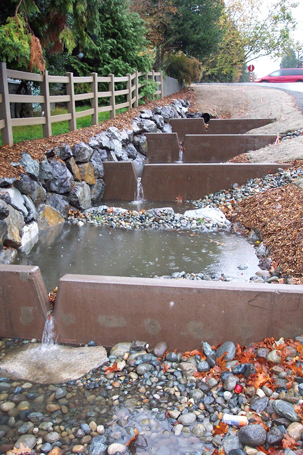
17 hours ago, PaulChinetti said:They’ve added all these cross members to the curbs on 12 South. Not sure why, anyone know?
These should essentially work like check dams that will help reduce the velocity of the water in the drainage swales. Rather than having the water enter the swale and immediately flow to the end, they'll pond up in little pools where it's more likely to be absorbed by the soil and greatly reduces the chance of erosion. Seattle is the first place that came to mind that does this pretty frequently with their road design.
-
10
-
7
-
- Popular Post
- Popular Post
You have to think that part of what went into Nashville being chosen as their next hub (as opposed to Atlanta or Charlotte) is geography and how close they are to much of the midwest and south. Part of the reason In-N-Out has never expanded past their west coast and Texas/Colorado locations is they refuse to put stores any further than ~800 miles from their distribution hubs - any further than that and they're unable to guarantee their food to be as fresh as it is. They didn't have any presence in Texas until they opened a Dallas distribution center about a decade ago.
Setting up shop in Nashville means they can open up locations all through the central and eastern United States, even if they still can't reach places like the northeast.
-
9
-
- Popular Post
- Popular Post
Did a little digging and found the build out plans for the space facing Hermitage - looks like the retail space is still going to be unfinished. Instead, AI Corporate Interiors is just building out an office space in part of the first floor. I've attached the full set of plans for anybody who's interested.
-
5
-
1
-
1 hour ago, smeagolsfree said:
Was this a recent plan? It was referencing the rebuild of I 440 which has already been done. So, I am thinking this is an old plan.
On a similar note, the Gov and TDOT are expected to have a new spending plan announced this week, I think. Let's see how much of this is in there.
This is from the list of projects that TDOT released a month or two ago that don’t have any funding but that they surmised could be built using the private-public partnership idea that they just came out with. I think there was a lot of discussion on the document in the Transportation and Mass Transit thread.
Regardless - this is a recent proposal, but it’s one without a funding source and one that I can’t imagine will have any real momentum any time soon.
-
2
-
1
-
-
My understanding is that Harper's is going in to the other retail space along Peabody, which is facing Lea Ave (also towards the trolley buildings, Pinewood Social, etc.). That space has been in the process of being built out for the past 4-5 months.
There's an internal hallway separating the two retail spaces which will keep them from being combined, so some other business should be going in to the space facing Hermitage. Seems like there's already an agreement in place since, as you said, a contractor just recently started building out that space as well - I'll be curious to see what goes in there.-
1
-
1
-
-
11 hours ago, Mr_Bond said:
Next week, Terrazzo residents will have a complete survey done of all units so that the 'before' condition can be documented pre-blasting. Has anyone heard of this being done in Nashville before?
They did this at Peabody Plaza before Peabody Union started blasting a few months ago.
-
1
-
-
2 hours ago, Nathan_in_DC said:
Holy crap, don't look at the price estimates on some of these. For instance, $1.4 million to add sidewalks to Eastland between 16th and 17th Streets. That seems excessive, even if they're burying utilities in the process.
With many sidewalk projects the majority of the cost does not come from the concrete going on the ground, it's the drainage. If the existing roadway utilizes a ditch, then we're talking about putting a curb and gutter drainage system in where one doesn't exist today. That involves excavation, expensive concrete structures and pipes, and then connecting that new storm drainage system into other storm drainage systems that are existing today (which often means going outside the immediate project area to adjust existing drainage structures and connect to them). $1.1M for that little stretch of sidewalk certainly seems excessive, but the "per linear foot" costs are higher when you get to these small projects and with how construction costs have skyrocketed recently it doesn't seem too far out of whack.
-
1
-
1
-
-
12 hours ago, satalac said:
Has anyone heard any news on the possible Buccees on Joe B Jackson or the massive sports facility on Broad in Murfreesboro?
Moving forward!
-
1
-
2
-
-
4 minutes ago, Archibum said:
Pretty sure this is an actual real physical model, which would lead me to believe it is probably a little outdated. Looks like it was used as a sketch model to test ideas and easily swap things in an out. The renderings and plans in the publication would undoubtedly be the most up to date
This is spot on - the caption for the image in the Tennessean does mention it's a small-scale physical model instead of 3D rendering.
-
2
-
-
- Popular Post
- Popular Post
16 hours ago, GregH said:I am repeating myself in here but Airport-Downtown seems like a big mistake if you're trying to build support locally. How am I supposed to benefit from that as a local? Downtown would be the worst-possible starting place for my trip to the airport. The only thing I can think of is maybe wishful thinking about reduced traffic on I-40 but I think that's a stretch. If you want locals to like transit you need transit a lot of locals will use a lot and realistically that means something going from somewhere close to where a lot of people live to somewhere close to where a lot of those people work.
I think one thing that could really improve the utility of an Airport-Downtown line for locals is to make sure there are a couple of stops along the way. The most likely route will be along Murfreesboro Pike - adding some stops would help the transformation to a more pedestrian/transit-friendly corridor as developers are already starting to buy up land out there. It would also have the added benefit of providing some additional jump-on points for locals to use as a way to get into downtown or to the airport cheaper/easier.
-
7
-
2 hours ago, titanhog said:
Yeah…I can’t think of any teams building actual closed domes anymore. I’m pretty sure most (if not all) are retractable. Really like having best of both worlds…but like Ron said…I’m sure it’s quite a difference in cost and maintenance.
The only recently built closed dome that comes to mind is Allegiant Stadium in Las Vegas for the Raiders. That one is completely enclosed.
-
1
-
1
-


New Titans Stadium (60,000 capacity dome, ground level retail, directly east of Nissan Stadium)
in Nashville
Posted
Playing field will be close to at grade with existing 2nd St elevation. Won't be digging a hole like the existing Nissan Stadium has, so this building will be much taller.